Highly detailed topographical maps for Burma and Yunnan:
1. China and Yunnan
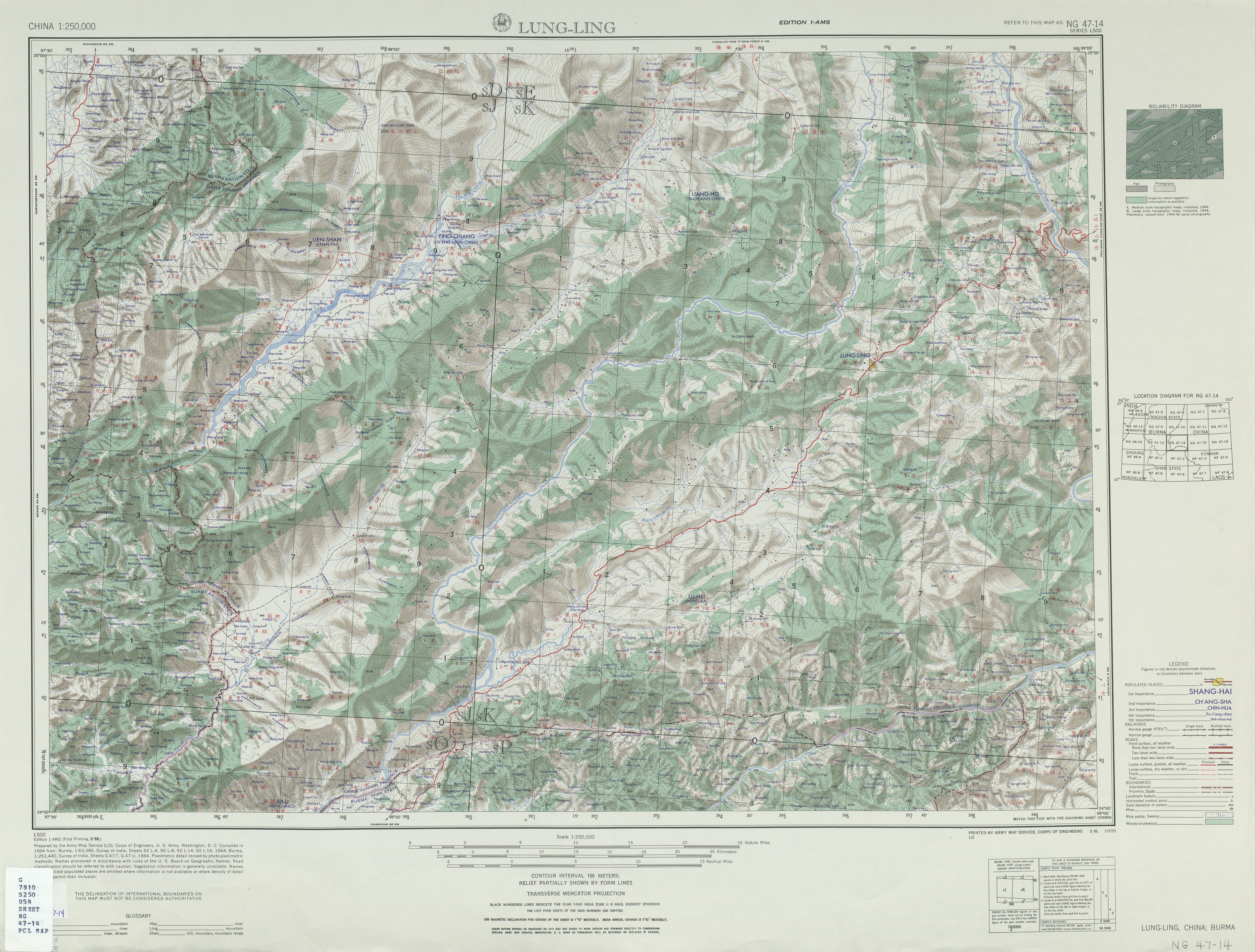
Mong Mao is on this map. This set of maps is certainly in need of a better index. Will have to work on one myself. A better map reader than internet explorer's zoom capbility is needed too. Would be nice to make a more detailed map than Wade's Ming Shi-lu map that shows the role that topography played in history.
2. Burma
Maps:
NC 47-2 Bokpyin (4.4 MB)
NC 47-6 Kra Buri (4.6 MB)
ND 46-4 Ama (3.9 MB)
ND 47-2 Ye (6.2 MB)
ND 47-6 Tavoy (5.8 MB)
ND 47-10 Palauk 1959 ed. (5.8 MB)
ND 47-10 Palauk 1962 ed. (4.9 MB)
ND 47-14 Mergui (4.6 MB)
NE 46-3 Kyaukpyu (6.5 MB)
NE 46-4 Thayetmyo (6.6 MB)
NE 46-7 Sandoway (5.0 MB)
NE 46-8 Prome (6.9 MB)
NE 46-12 Henzada (6.6 MB)
NE 46-15 Sinma (3.8 MB)
NE 46-16 Bassein (6.3 MB)
NE 46-16 Bassein and Vicinity [verso] (961K)
NE 47-1 Pyinmana (6.9 MB)
NE 47-5 Toungoo (6.8 MB)
NE 47-9 Pegu (6.3 MB)
NE 47-13 Rangoon (5.6 MB)
NE 47-13 Rangoon and Vicinity [verso] (1.1 MB)
NE 47-14 Moulmein (6.2 MB)
NF 46-3 Mawlaik (6.5 MB)
NF 46-4 Wuntho (6.4 MB)
NF 46-7 Gangaw (6.2 MB)
NF 46-8 Shwebo (5.9 MB)
NF 46-10 Cox's Bazar (5.9 MB)
NF 46-11 Mount Victoria (6.4 MB)
NF 46-12 Myingyin (5.7 MB)
NF 46-14 Akyab (4.1 MB)
NF 46-15 Myohaung (6.6 MB)
NF 46-16 Yenangyaung (6.1 MB)
NF 47-1 Mong Mit (6.6 MB)
NF 47-2 Hsenwi (6.4 MB)
NF 47-5 Maymyo (6.4 MB)
NF 47-6 Mong Yai (6.5 MB)
NF 47-9 Mandalay (6.3 MB)
NF 47-9 Mandalay, Burma and Vicinity [verso] (1.6 MB)
NF 47-10 Lai-Hka (6.2 MB)
NF 47-11 Keng Tung (6.7 MB)
NF 47-11 reliability diagram, notes, glossary [verso] (1.1 MB)
NF 47-13 Yamethin (6.4 MB)
NF 47-14 Mong Pan (6.7 MB)
NG 46-8 Sibsagar (5.7 MB)
NG 46-12 Tamanthi (5.4 MB)
NG 46-16 Paungbyin (5.9 MB)
NG 47-1 Putao (6.1 MB)
NG 47-5 Maingkwan (5.9 MB)
NG 47-9 Myitkyina (5.9 MB)
NG 47-13 Bhamo (5.9 MB)
skip to main |
skip to sidebar
The history of Burma and the Tai states on its frontiers (c. 1350-1600) and connections to Ming Dynasty Yunnan to the north and the Bay of Bengal to the south. The use of historiography and technology to investigate this time period and region are also covered.
About Me

Papers
Histories
Historians
Historiography
Links
Blog Archive
-
▼
2007
(21)
-
▼
March
(8)
- Vickery on Coedes' history of Cambodia
- Bertil Lintner takes Susan Conway's new to task on...
- What philology means to some people
- Sealang.net for Burmese language dictionary and co...
- Topographical Maps for Burma-Yunnan border area
- Pictures of new Myanmar capital Nay-pyi-daw
- Money in Yunnan during the Ming (c. 1350-1600)
- Suhkothai history's relevance for Mon history of L...
-
▼
March
(8)